Облако тегов || TAGSCLOUD
Tag — Maps Облако тегов || TAGSCLOUD 06.11.2012 SYSTEM OF ANCIENT MONUMENTAL STRUCTURES. LATITUDES OF HISTORICAL OBJECTS. Комментарии: 0 | Теги: geolines research Maps 22.03.2012 Files for Google Earth Комментарии: 0 | Теги: Google Earth Maps 17.02.2012 JIM ALISON'S LINES Комментарии: 0 | Теги: geolines research Maps Облако тегов || TAGSCLOUD 19.11.2012 SOME FEATURES OF DISTANCES BETWEEN HISTORICAL OBJECTS Jim Alison in the article «A new view on the old project» described some interesting moments connected with an arrangement of well-known historical constructions. Comments: 1 | Tags: Maps Giza SAMS 13.11.2012 SYSTEM OF ANCIENT MONUMENTAL STRUCTURES. LATITUDES OF HISTORICAL OBJECTS. Part 2 The Grid No. 2 considered in this part, isn't less interesting, than the first. The network unites practically all most known monumental constructions of an antiquity and a set of other historical objects. Comments: 0 | Tags: Google Earth Maps SAMS 06.11.2012 SYSTEM OF ANCIENT MONUMENTAL STRUCTURES. LATITUDES OF HISTORICAL OBJECTS. In the previous publication «Geodesy of meridians» the regularities found in an arrangement of meridians of known historical objects were described. It became clear that meridians of such constructions, as the Great pyramid... Comments: 0 | Tags: geolines research Maps SAMS 23.08.2012 SYSTEM OF ANCIENT MONUMENTAL STRUCTURES. GEODESY OF MERIDIANS. Meridians of the most known ancient constructions have surprising regularities in the arrangement relatively each other. They are connected among themselves and form the accurate system similar to modern geodetic system Comments: 1 | Tags: geolines Maps SAMS 02.06.2012 ORIENTATION OF TEMPLES IN THEBES AND VALLEY OF KINGS In recent years there is growing evidence that well-known historic objects are located on our planet not chaotically, but with a definite system. Comments: 0 | Tags: Google Earth geolines research Maps 17.02.2012 JIM ALISON'S LINES Alfred Watkins, who discovered the leis lines in England, laid the beginning for the new direction of research related to the geographical location of historic objects. Comments: 1 | Tags: geolines Maps SAMS 16.12.2011 GEODESY OF HEXAGRAM Hexagram is the most ancient mathematical symbol, known to mankind throughout millennia. It is considered that this international symbol has been found for the first time in India where it was used before has appeared in Europe and in the near east. Comments: 0 | Tags: geolines Maps SAMS Облако тегов || TAGSCLOUD 15.01.2013 LINES OF THE GREAT PYRAMID This publication describes some of the patterns of lines - great circle connecting the Great Pyramid with the main points of the system. Namely, Teotihuacan, Uluru, Stonehenge, Tiwanaku, Easter Island, Nan Madol, Baalbek and Angkor. Comments: 0 | Tags: geolines Maps SAMS Облако тегов || TAGSCLOUD 18.01.2013 LINES OF THE GREAT PYRAMID Due to the fact that the most significant buildings of antiquity were built on our planet is not chaotic, but as it turned out , in certain places Comments: 0 | Tags: geolines research Maps 08.11.2012 Yanshang stone plate is oriented on Teotiuacan The second megalit of a complex has the extended rectangular shape, is well visible from space and is cut on an azimuth of 40.3 degrees, which sets in this point the direction on Teotiuacan. Comments: 1 | Tags: geolines research Maps 03.04.2012 Spotting Ancient Sites, from Space For decades, working as an archaeologist meant being, as Jason Ur, the John L. Loeb Associate Professor of the Social Sciences, puts it, "the guy with the muddy boots." Comments: 0 | Tags: Google Earth Maps
06.11.2012 SYSTEM OF ANCIENT MONUMENTAL STRUCTURES. LATITUDES OF HISTORICAL OBJECTS.
Комментарии: 0 | Теги: geolines research Maps
22.03.2012 Files for Google Earth
Комментарии: 0 | Теги: Google Earth Maps
17.02.2012 JIM ALISON'S LINES
19.11.2012 SOME FEATURES OF DISTANCES BETWEEN HISTORICAL OBJECTS
Comments: 1 | Tags: Maps Giza SAMS
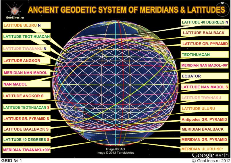
13.11.2012 SYSTEM OF ANCIENT MONUMENTAL STRUCTURES. LATITUDES OF HISTORICAL OBJECTS. Part 2
Comments: 0 | Tags: Google Earth Maps SAMS
Comments: 0 | Tags: geolines research Maps SAMS
23.08.2012 SYSTEM OF ANCIENT MONUMENTAL STRUCTURES. GEODESY OF MERIDIANS.
Comments: 1 | Tags: geolines Maps SAMS
02.06.2012 ORIENTATION OF TEMPLES IN THEBES AND VALLEY OF KINGS
Comments: 0 | Tags: Google Earth geolines research Maps
16.12.2011 GEODESY OF HEXAGRAM
Comments: 0 | Tags: geolines Maps SAMS
15.01.2013 LINES OF THE GREAT PYRAMID
18.01.2013 LINES OF THE GREAT PYRAMID
Comments: 0 | Tags: geolines research Maps
08.11.2012 Yanshang stone plate is oriented on Teotiuacan
Comments: 1 | Tags: geolines research Maps
03.04.2012 Spotting Ancient Sites, from Space
Comments: 0 | Tags: Google Earth Maps
ТОЛСТАЯ МОГИЛА
Tovsta Mohyla Burial
Юаньминъюань
Yuan Ming Yuan
HISTORY ON-LINE
LAST COMMENT
USEFUL NEWS
19.01.2019 Effective ways to improve health
Комментарии: 0
19.01.2019 Drink mineral water
19.01.2019 Red fruits charge antioxidants